
Updated August 2026: Elk Creek Trail is a moderate hiking and mountain-biking route in the Tillamook State Forest, beginning near Elk Creek Campground off Oregon Highway 6. The official Oregon Department of Forestry guide measures four miles from the trailhead to the Elk Mountain Trail junction, so a complete out-and-back is about eight miles—not the 6.9 miles previously listed here.
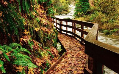
You do not have to hike the entire route. The first section follows Elk Creek and the West Fork through alder, sword fern and mossy Coast Range forest, making a shorter turnaround worthwhile. Compare this route with other options in our Oregon hiking guide.
Elk Creek Trail quick facts
- Full distance: About 8 miles round trip to the Elk Mountain Trail junction and back.
- Shorter option: Choose your own turnaround along the creek corridor.
- Difficulty: Moderate on Elk Creek Trail; connecting ridge routes are much harder.
- Uses: Hiking and mountain biking.
- Setting: Tillamook State Forest near Highway 6 and Elk Creek Campground.
- Conditions: Mud, fallen trees, active forestry operations and temporary closures are possible year-round.
Hiking Elk Creek Trail
The trail begins on an old road beyond the large boulders at the far end of Elk Creek Trailhead. For the first half mile it follows the main fork of Elk Creek, then passes the confluence with the West Fork. Red alder, sword fern and damp canyon walls define this lower section.
The route stays near the West Fork for roughly another mile before climbing out of the canyon. Douglas-fir becomes more prominent as the trail switchbacks west, turns north and eventually reaches the ridgeline and the Elk Mountain Trail junction at about four miles.
Do not confuse Elk Creek Trail with Elk Mountain Trail
Elk Creek Trail and Elk Mountain Trail share the same trailhead but offer very different days. Elk Creek begins on the old road beyond the boulders. Elk Mountain starts behind the information board and climbs about 1,900 feet in only 1.5 miles on a steep, narrow route. The ridge connections toward Elk Mountain and Kings Mountain include loose rock, exposure and scrambling; they are not a casual extension of the moderate creek trail.
Study the official ODF Elk Creek, Elk Mountain and Kings Mountain trail guide before combining routes.
Wildlife and forest conditions
Elk use this part of the Coast Range, and hikers may see tracks, droppings or antler rubs even when the animals stay out of sight. Steelhead use Elk Creek, and river otters have also been observed in the drainage. Give every animal space, keep pets controlled and never block an animal’s route away from the trail.
The Tillamook State Forest is also a working forest. Logging traffic, active operations, storm damage and fire restrictions can affect roads and trails. ODF says Tillamook trails are generally open year-round, but temporary closures still occur. Check the current Tillamook State Forest trail report before leaving.
Getting to Elk Creek Trailhead
- Travel Oregon Highway 6 to approximately milepost 28.
- Turn north onto Elk Creek Road.
- Continue through the campground and across the bridge to the signed trailhead.
- Use the old road past the large boulders for Elk Creek Trail; the steep Elk Mountain Trail begins behind the information board.
Forest-road and campground access can change, so use the latest ODF directions rather than relying only on a saved pin. Lock your vehicle, leave valuables out of sight and do not block gates or emergency access.
What to bring
- A downloaded official map and a clear turnaround plan.
- Water, food, rain layers and traction for mud.
- The Ten Essentials for the full route or any ridge connection.
- A way to communicate your plan to someone who is not on the hike.
Stay on designated trails, pack out everything you carry in and follow the Leave No Trace principles. For more choices around the state, return to our complete Oregon hiking guide and trail map.